
Aobayama New Campus Plan


Framework Plan
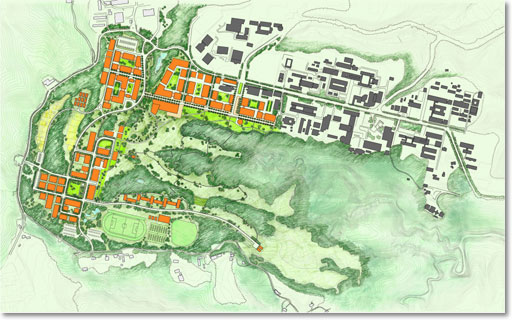
△Framework Plan
The Framework Plan shows the basic land usage of the Aobayama New Campus Development and based upon the following five ideas in the "Fundamental Plan".
●Consider rich natural environment
The Aobayama New Campus Project is for a 'Environmental-Harmony-Campus' which aims for protecting the rich natural environment of Aobayama and is a popular symbol to its citizens; known as the "City of Trees, Sendai".
On the other hand, since the site has once been developed as a golf course, the land is clearly divided into two categories, as the preservation green lands and the development/ building areas. The development/building areas are planned to be constructed in high density leaving the preservation areas to maintain its current environment for the next 100 years.
●Exploit natural geographical features
The development areas are basically planned sympathetic to its natural geographical features, restraining large-scale development site as much as possible, using only the fairway of the former golf-course.
●Integrate with existing campus environment
In campus planning, the relations of educational/research functions and the natural environmental continuity between the New and existing Aobayama/Kawauchi Campus are planned accordingly.
●Open to the public
Opened to the public is the vast open space of nature in the blend of the 'University Park' and Tatsunokuchi ravine.
●Promote the use of public transportation
The East-West Subway Line is scheduled to open in year 2015 and its use in the promotion of public transportation in the planning of Aobayama and Kawauchi Campus.
Site Condition
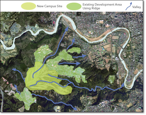
The New Campus consists of the ridge and valley of Aobayama which includes the existing Aobayama and Kawauchi campus; it is part of a large circulation of natural ecosystems and is designed consciously as part of a large water circulation. Considering the importance of the watershed, much of the campus developments are influenced by the current water ecosystem and are kept to the smallest as much as possible.
Examination of Developable Areas
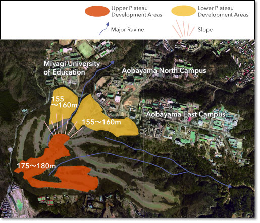
Two levels of developable areas are separated by valleys and other natural geographical features which are set aside as the Upper and Lower Areas of Plateau Development. The Lower Plateau Area is 155~160m above sea level, it is located in the northeastern part of the site consecutive to the existing Aobayama Campus and the Miyagi University of Education to its north. The Upper Plateau Area is 175~180m above sea level, it is located in the southern part of site connected with hills in the hinterland. The fairways of the former golf course are found in the two Plateaus Development areas which are mainly planned for development.
>>>Click for Details : Developable Areas and Land Use Zones
Study of Road Shape
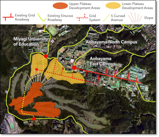
●Analysis of Road Shape to the Surrounding
The roads of the Aobayama East Campus are designed in grid fashion although its approaches and the outgoing roads to Aobayama North Campus and the New Campus are curved sinuous following the natural geographical features of the land. The new campus roads are planned in view of the existing campus road and network system.
●Introduction of Grid System
The grid pattern of Aobayama East Campus extends from Aobayama Station on the East and extends towards to the west and as a result, facilities around the Subway Station are designed for high density. Moreover, the connecting green land around Tatsunokuchi ravine, in the new and existing campus, remain as the main axis line cranking from Aobayama Station and in the direction of Tatsunokuchi ravine.
●A landform which ties two areas
The area in the north and south parts of the New Campus are tied together with an "S Curved Avenueモ which runs the geographical features of the site. The avenue starts in the vicinity of the Miyagi University of Education Front Gate and runs along side the Sankyo stream; it was built with only small amounts of modification to the natural geographical features in mind.
>>>Click for Details : The road framework and open space of the campus
Development on Five Areas and the University Park
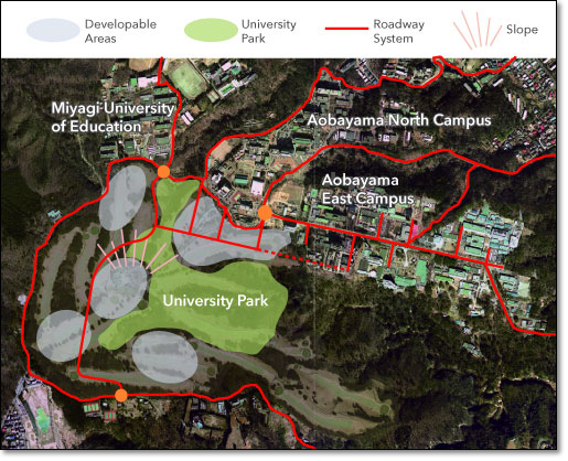
The Whole New Campus has its own unique identity. By examining the development of the New Campus Site as mentioned above, the five areas are all found roughly divided by the framework of the campus road. Each campus plan features the best usage of the land and face the large central green land which is called "University Park".
>>>Click for Details : Developable Areas and Land Use Zones
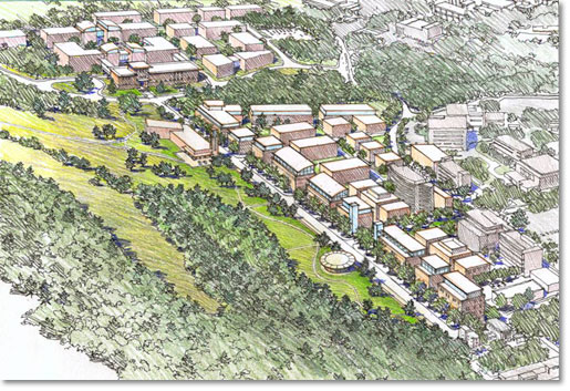
△Bird's-eye view 1
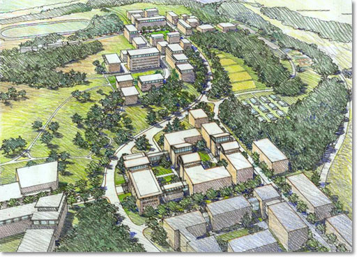
△Bird's-eye view 2
- Possibilities of future changes are made through examinations; they concern the images, building arrangement, shapes etc. included in this publication.