
Aobayama New Campus Plan


Environmental Analysis


Terrain
●Altitude and Slope Distribution
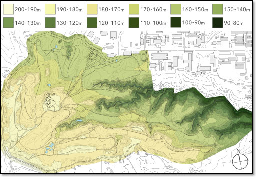
△Altitude
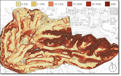
△Slope Distribution
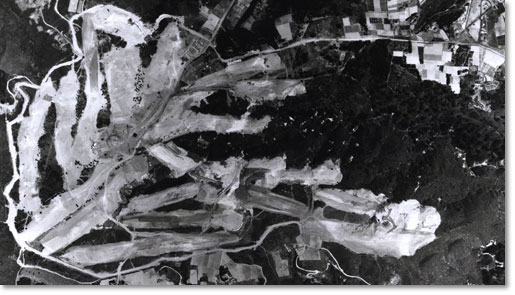
△Site making golf course (aerophotograph
The New Campus is located in the place of violent undulation near the top of Aobayama, and in the upstream in the branch of Tatsunokuchi ravine including about 30m high cliff. The New Campus is mostly hill above the sea 150〜180m.
The site of the New Campus is an uphill for northeast, has already been made as a golf course, and the fairway part is comparatively a flat land. In northeastern of the site following the existing Aobayama Campus, there is comparatively a flat land above the sea about 155m. Moreover, there is a plain above the sea about 175m also in the southwest of the site.
The steep slope where the ratio of the slope passes 20% is distributed on the surrounding of Tatsunokuchi ravine and the west edge of site. And, the part of 10 to 20% of slope has extended continuously in this.
Area where sand flows out to the valley, and the influence on the ecosystem might be caused doesn't modify land as much as possible. (Especially, ratio part of 20% or more of slope around Tatsunokuchi ravine, etc.)
●Tree Distribution
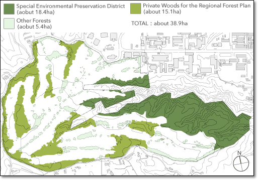
△Tree Distribution
Areas around the New Campus have rich natural environment such as "Aobanomori-ryokuchi" and "Tatsunokuchi ravine ".
Green land areas in the New Campus are divided into "Special Environmental Preservation District", "Private Woods for the Regional Forest Plan", and "Other Forests."
●Network System of Water
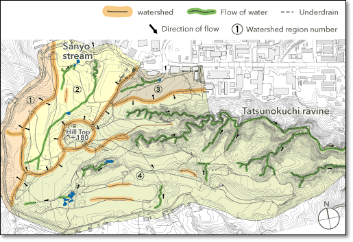
△ Network System of Water
Most rivers in Sendai City run from the Ohu Mountains, where exist the source of the rivers in the boundary with Yamagata Prefecture, from west to east, and into the Pacific Ocean. These water systems are roughly divided into three systems (from the north, the Nanakita Water System, Hirose Water System, and Natori Water System), and a New Campus belongs to the Hirose Water System.
By the slope, Rain water runs "to the west side road for watershed region 1(west edge of the site)", "to Sankyozawa water system for watershed region 2 (centeral and northern part)", "to the north side road for watershed region 3 (northwest)", "to Tatsunokuchi ravine water system for watershed region 4 (centeral and southeast).
Climate
The difference of heat and cold is few because of a coast climate of the Pacific Ocean. And, because the wind in the northwest that crosses the Ohu Mountains in winter and blows is dry, the snowfall is a little.
●Temperature and Snow
The lowest temperature might become under the freezing point in winter though it snows little. Therefore, it is necessary to consider the measures such as freezing roads enough.
●Wind
The wind in the northwest from the sea in summer and in the southeast from the mountain in winter is known to be strong. Especially, the sea breeze of the middle season is a low temperature, and The rainy season of Sendai is cool.
●Durations of Sunshine and Quantity of Insolation
The quantity of solar radiation of the year of Sendai of the average is 104.9 kwh/㎡ and a value close to the mean value of Japan. Moreover, the precipitation in winter is a little, and the quantity of insolation can be secured to some degree in winter. The photovoltaic generation can be expected all year arround in an excellent place of the insolation condition.
Social Environment
△Social Environment (It can see the close-up by clicking.)
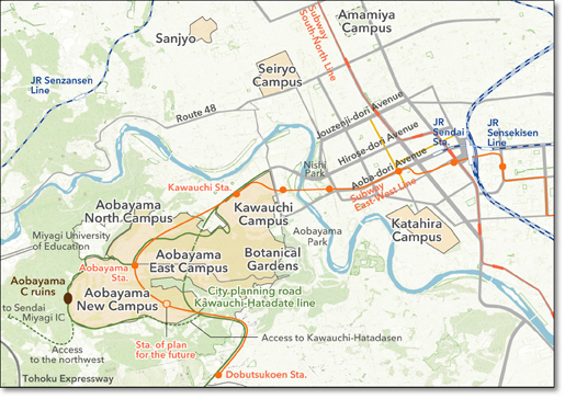
●Existing Campus and Surrounding Areas
It is necessary to attempt the land use with the oneness that considers continuousness with the relation between the Aobayama and Kawauchi Campus, especially the Aobayama East Campus. And, when the Aobayama Station of the Subway East-West Line opens, the use of students and faculty at Miyagi University of Education and local community is expected. It is necessary to plan the campus that considered the use of the public.
●Preservation of historical surroundings
In the New Campus west side, there are Aobayama C ruins registered as paleolithic ruins, and Kyokubumasei Celt is gathered. The Campus will be appropriately developed along the flow of the procedure of the buried cultural property in the future.
●Aobayama Station: Subway East-West Line
"Sendai-city Subway East-West Line Aobayama Station" (opening schedule in 2015) is scheduled to be constructed in the New Campus. East-West Line is a route that passes vicinity of the southwest of Yagiyama Zoo, The Aobayama Station, Kawauchi Station, vicinity of Sendai Station, east interchange on the east part of Sendai road, and vicinity of the Sendai port. The improvement of the transportation convenience is expected as it becomes easy to access from the central Sendai. Moreover, the installation of a new station in the southern part of New Campus is hoped for in the future.
●City Planning Road Kawauchi-Hatatate line
City Planning Road Kawauchi-Hatatate line, which is underconstructing, is scheduled to pass over the site east side by the underground type. The construction of access road to this planned road and access road to the northwest is hoped for to improve the convenience of New Campus.
View and Scenery Resource
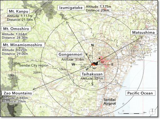
△Scenery resource around New Campus
(When this figure was made, the topographical map of 1/200,000 of the Geographical Survey Institute issue was used. )
As for the surrounding of the New Campus, "Pacific Ocean (east)", "Gongenmori and Taihakusan (west)", and "Izumigatake and Zao Mountains (It is far)", etc. are located, and the view is rich.
Especially, even urban area in Sendai and Pacific Ocean are looked at from the plateau around an old clubhouse in the direction of Tatsunokuchi ravine, and a magnificent scene (including night view etc.) can be expected.